Saturday, December 12, 2009

It's getting colder!

Its true, its actually getting very cold here! But I also said that because this week was the "dreaded" week of weather. Lets just say that our class got more sleep than usual this week!!

Monday: We started with our block 3 exam, which was based on all the materials from last week (Charts, FARs, and Navigation). I scored 100% on the exam, and I was the only one to do so.

We covered two non-weather units today, the first of which was "Introduction to Emergencies." This lesson is literally as easy as it sounds. For example, what do you call it when an aircraft has a situation that requires immediate attention/assistance due to a situation on board? Aircraft in Distress. There was more to it than just the simple definitions, but this was one of our easier lessons.
The second lesson of the day was "Search and Rescue," which required a little more attention, only because the rules vary depending on the type of flight plan. The national search and rescue plan pools the resources of several different agencies, and we needed to learn how each agency contributes towards search and rescue of missing aircraft.
We finished both lessons early, and since we can't technically start weather until the weather service teacher got there, we spent the afternoon reviewing our first 3 blocks (At this point, we are less than 10 days away from the cumulative final, so we wanted to review stuff from the first couple weeks of class).

Tuesday-Friday: Welcome to the slowest days of class EVER. For every basics class, they have a teacher from the National Weather Service (Norman, OK) come teach us 3.5 days of weather fundamentals. Our teacher was an extremely knowledgeable and frinedly gentleman, however, he was the most boring teacher that we've had to date. Every day during weather, there were several people who dozed off at one point or another, and our Contract instructors seemed to even expect this lol. It was bad, however, at the end, we did learn quite a bit about weather.
The first unit was the fundamentals of weather (how the atmosphere works, winds, clouds etc.). Next we studied weather hazards (Thunderstorms, fog, IFR conditions, snow, volcanic ash etc.). The next 3 units were all aviation related: METARS, TAFs, FAs, Winds Aloft, SIGMETS, AIRMETS, Convective SIGMETS, CWAs, MISs,PIREPs and more!!! I'll cover a few of the basics.

METAR: this tells the current conditions at a weather observation facility. We had to learn how to decode the METARs, and also learn how to properly phrase them when required. For example, here is the current METAR for BWI:
METAR KBWI 122254Z 18004KT 10SM BKN200 02/M12 A3054 RMK AO2 SLP344 T00221122

What does it all mean?? Well, here is how I would read that to you as an ATC:
Baltimore, two-two-five-four observation: Wind one-eight-zero at four, visability one-zero, ceiling two-zero thousand broken, temperature two, dew point minus one-two, altimeter three-zero-five-four. Remarks: Sea Level pressure One zero three four point four.

Sounds like fun, right? :) SURE.
There are other weather reports that forecast the conditions within the next 24 hours, within 5 miles of an airport, and they are called TAFs or Terminal Aerodrome Forecasts. Here's an example of the current TAF for BWI:
KBWI 122328Z 1300/1406 18004KT P6SM BKN200 
FM130400 15002KT P6SM SCT100 OVC150
FM131000 15002KT P6SM BKN035 OVC050
FM131300 14005KT 4SM -RA BR BKN015 OVC025
FM131600 16008KT 2SM -RA BR OVC008
FM132100 21006KT 3SM -RA BR OVC010
FM132300 18003KT 3SM BR OVC009
FM140500 30005KT P6SM BKN025
Who wants to try to translate? Basically, any time a significant change is forecasted within an hour, the next change is issued in a 'from' or FM statement. For example, if you look at the difference between the third and fourth line, the fourth line reads: From 1pm on the 13th day, wind 140 at 5 knots, visibility 4 statute miles, Light Rain showers and mist, ceiling at 1500 broken, overcast at 2500. note: how I just translated that was a loose translation, and not proper ATC phraseology!!

Anyways, thank goodness the weather week is over. We have a block test on all this material Monday, which should make for a fun weekend of studying.

Saturday: After our 'traditional' Saturday afternoon lunch with the class, I drove upto Stillwater OK to visit Adam Bates, a very close friend from College, who is now the Kappa Kappa Psi National Chapter Field Representative. Adam was nice enough to give me the tour of the Fraternity headquarters, give a small lesson in Stillwater/Frat history, and then treat me to dinner at the one and only Eskimo Joes. I highly recommend the Peppered-Bacon Cheese Fries. We finished the evening with some beers at a lounge while watching the Big-12 champhionship, and then continued the fun back at Adams house. I have had a great time in Oklahoma up to this point, but it was a nice touch of home to see another person from MD in Oklahoma. OF course, Adam has lived here for almost 2 years, so he's got some time on me, but it was still great nonetheless. I'm definitely looking forward to getting home to see everybody else next month!!

Next week is our last week of basics!!

Sunday, December 6, 2009

Thanksgiving week!

Sorry its taken me so long to get everyone updates...I've been a little busier, and I've also just been slacking on the blogging!

This week is a short week, since we get Thursday off for Thanksgiving, which is nice!
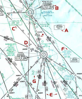
Monday & Tuesday: We Continued our lessons on VFR/IFR charts, which is essentially re-learning how to read a map, designed for aviation. Under VFR (Visual Flight Rules) and IFR (Instrument Flight Rules), there are several different types of charts that a pilot can use. There are the Terminal or area charts, which show the most detail. These are for use in populated/congested area with lots of traffic. This would be analogous to the map of New York City within the state map of NY. Then there are VFR Sectional charts & VFR World Charts, which have a larger scale, so they have less detail. These are for use by slightly faster aircraft, but still in VFR conditionsl. For IFR (beyond the terminal Area), there are Low & High En Route charts. Under IFR conditions, a pilot doesn't need to look out the window for navigation, so these charts don't have as many details (ie. obstructions, landmarks etc.). Instead, they display the proverbial "Highways in the sky". Below are examples of a VFR Sectional Chart and an En Route IFR Chart:


Wednesday: Our lessons on charts continued, however we moved to different types of Charts: STARs, SIDs, and Approaches. A STAR (Standard Termainal Arrival) is a published procedure that allows the standardized approach into the vicinity of an airport from high altitudes (en route). For example, those of you who live near Annapolis or Eastern Shore, you may always notice that the planes fly over your house at almost the exact same place and same altitude, one after another. This is because they are established on a published STAR, that is designed for the Baltimore area (if you really want to look it up, this is a link to the procedure: http://204.108.4.16/d-tpp/0912/00804RAVNN.PDF).

The next type of chart is the SID (Standard Instrument Departure), and SIDs serve a similar purpose as STARs, except they are deisgned for departures from an airport. For example, since we have 3-4 major airports in the DC area, you obviously can't have flights just flying wherever they want to! So instead, there are published procedures that guide you from the Terminal Environment (Airport) to the en route Environment (Cruising altitude). For any of you who fly out of Baltimore --If you are flying South or Southwest of Baltimore, then I can almost guarentee that your flight will take you: Over Columbia, North of DC/Gaithersburg, turn and then take a turn towards Dulles Airport before establishing on your flight. Here's a map of that procedure: http://204.108.4.16/d-tpp/0912/00804TERPZ.PDF. These procedures allow for more safety, efficiency, and can also reduce the workload for pilots/controllers.

The final type of chart we learned is an Instrument Approach Procedure (IAP): These are designed to allow the pilot to navigate directly to the runway in IFR conditions. The most commonly used for Commerical Airliners is called the ILS Approach (Instrument Landing System). An IAP will allow a pilot to tune into a navigational aid (ie. Radio beacon), and use that to fly directly to the airport, and there are two types: Precision and Non-Precision. Precision means that the Nav-Aid provides lateral and vertical guidance, and I'll explain: The instrument display shows the pilot exactly how far above/below the course he is, and it also shows how far left/right of course. So if you've ever heard a pilot tell you that the airplane can "land itself", that's really true, and its because of the precision approach. Non Precision approaches provide only lateral guidance, and because they aren't as precise (hence the name), you cannot fly as low in IFR conditions. Ask me if you want to learn more about this --I don't want to type out how everything works!! Its very interesting stuff though!

Thursday: Day off!! Happy Thanksgiving! We hosted a huge feast at my house, and it was a great success. I cooked almost everything, but my roomates were clutch with cooking the big meat (that's what she said?). We had Turkey, Ham, Stuffing, Carrots, Mashed Potatos/Gravy, Green Bean Casserole, Sweet Potatos, Chess Pie, Pecan Pie, and rolls. Mmm...delicious. Too bad we didn't have Friday off.

Friday: Today was a pretty big waste anyway --All non-ATC personnel took the day off, so the Academy was pretty empty...We were way ahead of schedule, so we had breaks almost every 30 minutes, which was nice. We had one lesson left in the block, which was "Pilots Environment." This lesson taught the basics of airplane systems and navigation. We finished the day with a review (our next block test is on Monday), and then went home for the weekend!!

Saturday, December 5, 2009

Updates coming soon...

Sorry -I've been a slacker for the past few weeks...I promise more updates are coming very soon! Stay tuned...